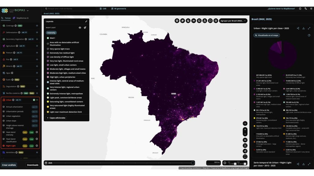
We are thrilled to share a major international milestone in the study and monitoring of light pollution. MapBiomas, a pioneering open and collaborative platform that transforms satellite data into long-term information on environmental and land-use changes, has officially released a groundbreaking Artificial Light at Night (ALAN) module as part of its Urban Collection.
This innovative tool was co-developed by a team of dedicated researchers, including PLAN-B collaborators Pawel Tysiac (Gdańsk University of Technology), Camila Palhares Teixeira (Universidade do Estado de Minas Gerais), and Vinícius Goulart (Universidade Federal de Minas Gerais). The release marks a massive step forward in mapping the nighttime footprint of human activities across South America, directly aligning with PLAN-B’s mission to address the global impacts of light pollution on biodiversity.
A New Perspective on Urbanization and Environmental Change
Monitoring environmental changes on the ground is an immense challenge in a continental-sized, highly biodiverse country like Brazil. By incorporating artificial light at night as a new dimension, the MapBiomas platform now features annual maps of nighttime radiance across Brazil spanning from 2013 to 2025.
This release allows scientists, urban planners, and conservationists to analyze urbanization from an entirely new perspective. Instead of focusing solely on physical land-cover transitions, users can now track the expansion, intensification, and encroachment of the artificial human footprint into urban, rural, and highly sensitive natural landscapes.
Bridging Science, Technology, and Environmental Decision-Making
Beyond its scientific value, MapBiomas plays a crucial institutional role in Brazil. The platform serves as a vital bridge between scientific innovation and environmental policy. Its datasets are widely utilized not only by researchers but also by:
- Government agencies and environmental authorities for policy design and enforcement.
- Private companies looking to assess environmental risks and plan sustainable territorial management.
- Civil society and NGOs advocating for darker, quieter, and more sustainable ecosystems.
Having a robust, continuous record of night light data across remote and protected regions empowers local authorities to make evidence-based decisions, safeguard wildlife corridors, and mitigate the ecological disruption caused by artificial light. This work is especially relevant to PLAN-B’s ongoing international efforts, as Belo Horizonte (Brazil) serves as one of the project’s key active pilot areas for citizen science and biodiversity mapping.
Explore the Data
The interactive datasets and mapping products are already publicly available and free to explore on the MapBiomas platform:
🔗 Explore the MapBiomas Brazil Nighttime Light Mod